
Table of Contents
These Geography questions for SSC MTS Exam 2024 are selected from a vast previous years’ question bank. The Multi-Tasking Staff Exam includes Geography in its Syllabus for the General Awareness section to test candidates’ understanding of the surroundings. The syllabus includes Indian Geography, World Geography, and Physiography.
The given SSC MTS Geography Questions aim to test your understanding across the sub-domains and prepare you well for the upcoming MTS Exam conducted by the Staff Selection Commission.
SSC MTS Geography Questions
Solve the following questions and find out how many you can answer correctly. To make the most out of these Geography Questions, make sure to read the detailed solutions and explanations at the end. It would be helpful if you analyze your strengths and weaknesses among various Geography topics like mapping, physiography, etc. Check the SSC MTS Syllabus here for more details about other subjects which you must practice to clear this exam.
Q1. The order of the layer of the atmosphere from the earth’s surface (moving away from the surface) is:
(a) Mesosphere – Troposphere – Stratosphere – Thermosphere
(b) Mesosphere – Stratosphere – Troposphere – Thermosphere
(c) Stratosphere – Troposphere – Mesosphere – Thermosphere
(d) Troposphere – Stratosphere – Mesosphere – Thermosphere
Q2. Silent Valley National Park is in which biosphere reserve?
(a) Dehang-Dibang
(b) Great Nicobar
(c) Nanda Devi
(d) Nilgiri
Q3. Which type of earthquakes occur in mining activities?
(a) Tectonic earthquakes
(b) Volcanic earthquakes
(c) Collapse earthquakes
(d) Explosive earthquakes
Q4. Saddle Peak, the highest peak of Andaman and Nicobar Islands, is located in?
(a) Great Nicobar
(b) Middle Andaman
(c) Little Andaman
(d) North Andaman
Q5. The northern part of the western coast is called ______.
(a) Kannad Plain
(b) Malabar Coast
(c) Konkan
(d) Coromandel Coast
Q6. Which of the following Indian islands lies in the Bay of Bengal?
(a) Andaman and Nicobar
(b) Daman
(c) Diu
(d) Lakshadweep
Q7. Choose the correct group of conventional sources of energy from the following
(a) Hydro power, geothermal energy, tidal energy
(b) Nuclear energy, solar energy, hydel power
(c) Oil, natural gas, firewood
(d) Coal, firewood, biogas
Q8. Coral reefs are not found in which one of the following regions?
(a) Gulf of Cambay
(b) Gulf of Kachchh
(c) Gulf of Mannar
(d) Lakshadweep and Minicoy Island
Q9. The Great Barrier Reef is the largest living thing on Earth and is even visible from outer space. It is located ____________.
(a) Near Seychelles
(b) In the Atlantic Ocean
(c) Near the Indian subcontinent
(d) Off the coast of Queensland in north-eastern Australia
Q10. Which among the following factors is/are responsible for the formation of Cyclones?
(a) Instability in the atmosphere
(b) Warm temperature at the surface of the sea.
(c) Only (a)
(d) Both (a) and (b)
Q11. Which of the following two States is prone to cyclones during the retreating Monsoon season?
(a) Karnataka and Kerala
(b) Punjab and Haryana
(c) Bihar and Assam
(d) Andhra Pradesh and Orissa
Q12. Arrange the following tributaries of the River Indus from North to South:
1) Chenab
2) Jhelum
3) Ravi
4) Sutlej
Select the correct answer using the code given below:
(a) 1-2-3-4
(b) 2-1-3-4
(c) 4-3-1-2
(d) 2-3-1-4
Q13. Which among the following is not the tributary of the Brahmaputra River?
(a) Shakkar River
(b) Manas River
(c) Teesta River
(d) Dibang River
Q14. ________ is the first state of India to receive rainfall by the southwest monsoon.
(a) Maharashtra
(b) Kerala
(c) Goa
(d) Gujarat
Q15. Which soil is the most widely spread soil in India?
(a) Laterite soil
(b) Alluvial soil
(c) Black soil
(d) Red soil
Q16. Moho’s discontinuity lies between
(a) Crust and core
(b) Mantle and outer core
(c) Outer core and inner core
(d) Crust and mantle
Q17. EL NINO Phenomenon is associated with:
(a) Cloud Bursting
(b) Earthquake
(c) Acid Rain
(d) Global Warming
Q18. Which one of the following statements with regard to Jet stream, an upper-level troposphere wave, is not correct?
(a) Jet streams are typically continuous over long distances.
(b) It follows the wave path near the tropopause at elevations of 8 km to 15 km.
(c) In summer, the polar front jet achieves its maximum force.
(d) It is a narrow band of high-velocity wind
Q19. In which continent is the country Brazil located?
(a) Europe
(b) South America
(c) Africa
(d) North America
Q20. Identify the continent from the given features A and B:
A. It is the smallest continent that lies entirely in the Southern Hemisphere.
B. It is also called an ‘Island continent’.
(a) Australia
(b) South America
(c) Antarctica
(d) Africa
Solutions
| Solutions of SSC MTS Geography Questions | |||
| 1. (d) | 2. (d) | 3. (c) | 4. (d) |
| 5. (c) | 6. (a) | 7. (c) | 8. (a) |
| 9. (d) | 10. (d) | 4. (d) | 5. (b) |
| 13. (a) | 14. (b) | 15. (b) | 16. (d) |
| 17. (d) | 18. (c) | 19. (b) | 20. (a) |
S1. Ans. (d)
Sol. The Earth’s atmosphere has a series of layers, each with its own unique characteristics.
The troposphere is the layer closest to the Earth’s surface, and it extends up to about 7 to 20 kilometers, depending on the location. The stratosphere is above the troposphere and extends up to about 50 kilometers. The mesosphere is above the stratosphere and extends up to about 85 kilometers. The thermosphere is the outermost layer of the atmosphere and extends up to about 600 kilometers.
So, the correct order of the layers of the atmosphere, from the Earth’s surface, moving away from the surface, is Troposphere – Stratosphere – Mesosphere – Thermosphere.
Exosphere – the outermost layer of the atmosphere. It extends from about 375 miles (600 km) to 6,200 miles (10,000 km) above the earth.
| Layer | Altitude Range |
| Troposphere | 0 km – 7/20 km |
| Stratosphere | 7/20 km – 50 km |
| Mesosphere | 50 km – 85 km |
| Thermosphere | 85 km – 600+ km |
S2. Ans. (d)
Sol. Silent Valley National Park is located in the Nilgiri Biosphere Reserve. Silent Valley National Park is a protected area located in the Palakkad district of Kerala.
- The Nilgiri Biosphere Reserve is a UNESCO-designated biosphere reserve located in the Western Ghats of India. It is spread over an area of about 5,520 square kilometers and includes parts of the states of Tamil Nadu, Kerala, and Karnataka.
- The reserve includes several protected areas, including national parks and wildlife sanctuaries, such as Silent Valley National Park, Mudumalai Wildlife Sanctuary, Bandipur National Park, and Nagarhole National Park.
- Dehang-Dibang Biosphere Reserve – Arunachal Pradesh, includes several protected areas, such as Mouling National Park, Dibang Wildlife Sanctuary, and Kamlang Wildlife Sanctuary.
- Great Nicobar Biosphere Reserve – located in the Nicobar Islands of India.
- Nanda Devi Biosphere Reserve – located in Uttarakhand, a UNESCO-designated biosphere reserve.
S3. Ans. (c)
Sol. The type of earthquakes that occur in mining activities are generally categorized as Collapse earthquakes.
| Type of Earthquake | Cause |
| Tectonic | Movement of tectonic plates in the Earth’s crust |
| Volcanic | Movement of magma beneath the Earth’s surface |
| Collapse | The collapse of underground mines, tunnels, or other cavities |
| Explosive | Detonation of explosives in mining, construction, or military activities |
S4. Ans. (d)
Sol. ‘Saddle Peak’, the highest peak of Andaman and Nicobar Islands is located in Diglipur, a town in North Andaman Island. Saddle Peak is the highest peak in the Andaman and Nicobar Islands, with an altitude of 732 meters (2,402 feet). It is located in Saddle Peak National Park.
- North Andaman Island is one of the largest islands in the Andaman and Nicobar archipelago, located in the northernmost part of the group. In addition to the Saddle Peak National Park, the island is also home to several other protected areas, including the Mount Harriet National Park and the Galathea National Park.
- The Andaman and Nicobar Islands are a Union Territory of India, located in the Bay of Bengal.
S5. Ans. (c)
Sol. The northern part of the western coast is called the Konkan Coast. The Konkan Coast is a stretch of the western coastline of India, extending from the state of Maharashtra in the north to the state of Goa in the south. The Konkan Railway, which runs along the coast, is one of the most scenic train journeys in India.
The Western Coastal Plains:
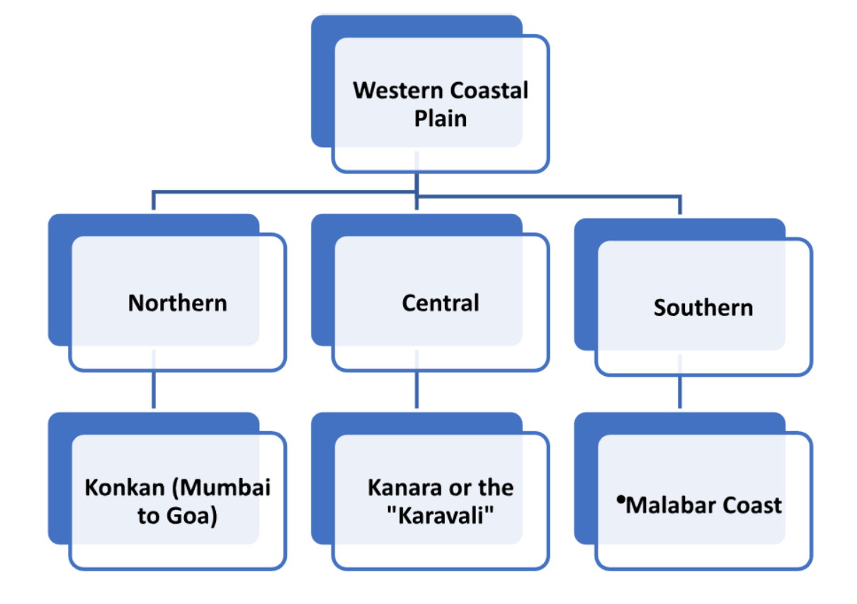
| Region | Location Along the Indian Coastline | Related States |
| Kannad Plain | Located in Maharashtra | Maharashtra |
| Malabar Coast | Located in the southwestern coast | Kerala, Karnataka, Goa |
| Konkan | Located on the western coast | Maharashtra, Goa, Karnataka |
| Coromandel Coast | Located on the south-eastern coast | Tamil Nadu, Andhra Pradesh, Puducherry |
S6. Ans. (a)
Sol. The Andaman and Nicobar Islands lie in the Bay of Bengal.
- Daman and Diu are located on the western coast of India, on the Arabian Sea. Lakshadweep islands are located in the Arabian Sea off the western coast of India.
- The Bay of Bengal is a large body of water located in the north-eastern part of the Indian Ocean, bounded by India to the west, Bangladesh to the north, Myanmar to the east, Sri Lanka to the south, and the Andaman and Nicobar Islands to the southeast.
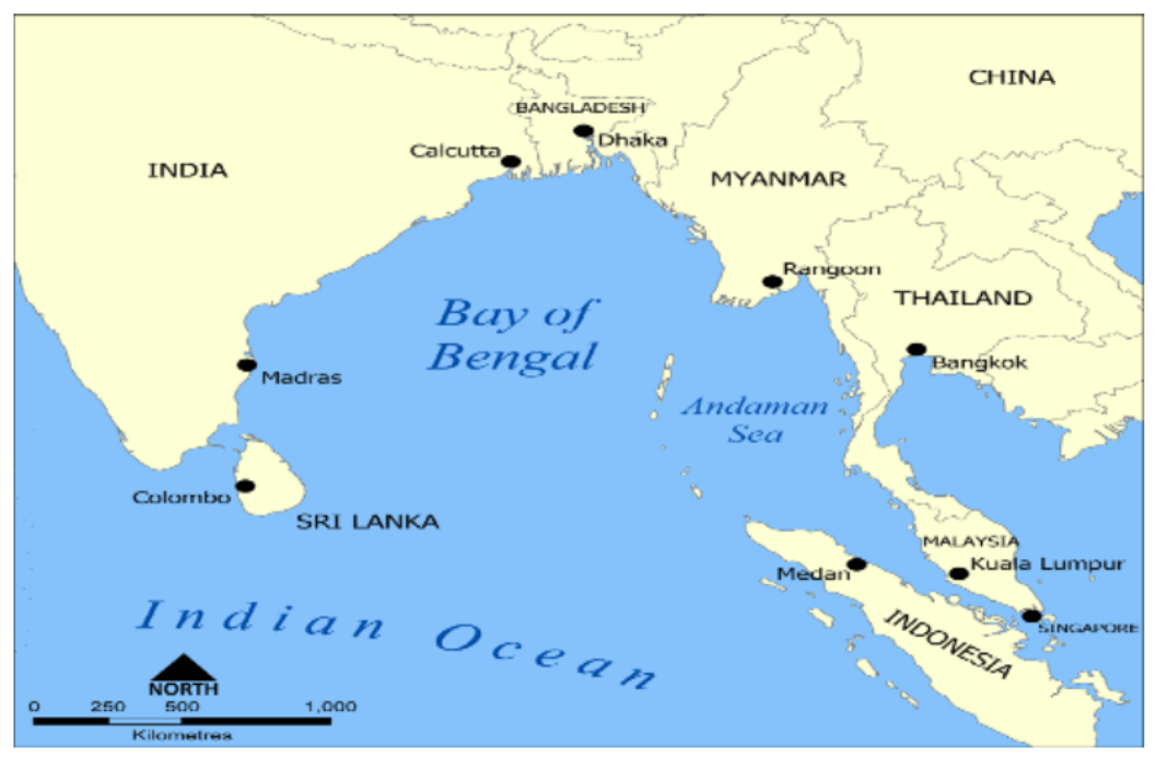
- Andaman and Nicobar Islands is a Union Territory of India, consisting of two island groups: the Andaman Islands and the Nicobar Islands.
- Port Blair on South Andaman Island is the capital city of the Andaman and Nicobar Islands.
S7. Ans. (c)
Sol. Conventional sources of energy are those that have been used for a long time and are widely available. Oil, natural gas, and firewood are all examples of conventional sources of energy. Oil and natural gas are fossil fuels, which are formed from the remains of plants and animals that lived millions of years ago. Firewood, on the other hand, is a renewable source of energy, but its use is considered conventional because it has been used for centuries as a source of heat and energy. Therefore, the correct group of conventional sources of energy is (c) Oil, natural gas, and firewood.
- Hydropower, geothermal energy, and tidal energy are examples of renewable sources of energy. Nuclear energy is not a conventional source of energy because it is a relatively new technology that has only been in use since the mid-20th century. Solar energy is also a renewable source of energy, but it is not considered conventional because it has only been widely used in recent decades. Hydel power is another name for hydropower, a renewable energy source.
S8. Ans. (a)
Sol. The Gulf of Cambay is located on the west coast of India (between the states of Gujarat and Maharashtra) and is known for its rich biodiversity and important ecosystems. However, coral reefs are not found in this region due to a variety of factors such as the high sedimentation rate, low salinity, and high turbidity of the water.
In contrast, coral reefs are found in the Gulf of Kachchh, the Gulf of Mannar, and Lakshadweep and Minicoy Islands, which are all located in the Indian Ocean.
- The Gulf of Kachchh, also known as the Gulf of Kutch, – located in the north-western part of the Indian Ocean, between the Saurashtra peninsula in the Indian state of Gujarat and the eastern coast of Pakistan.
- The Gulf of Mannar – located between the south-eastern tip of India and the northern coast of Sri Lanka.
- Lakshadweep and Minicoy Island: Lakshadweep – group of 36 coral islands located off the southwestern coast of India, in the Arabian Sea. Minicoy Island – the southernmost island in the Lakshadweep archipelago, known for its beautiful coral reefs.
S9. Ans. (d)
Sol. The Great Barrier Reef is located off the coast of Queensland, which is a state in north-eastern Australia. It is the world’s largest coral reef system and is home to a diverse range of marine life. Its size and colorful appearance make it visible from outer space, and it is considered one of the natural wonders of the world. It was selected as a World Heritage Site in 1981.
- Seychelles which is home to numerous beaches, coral reefs, and nature reserves located in the Indian Ocean, off East Africa.
S10. Ans. (d)
Sol. Cyclones are large-scale weather systems characterized by low atmospheric pressure at the center and strong winds circulating around it. They are also known as hurricanes, typhoons, or tropical storms, depending on their location and intensity.
The formation of cyclones requires two primary factors: instability in the atmosphere and warm temperatures at the surface of the sea. The warm ocean waters provide the energy that drives the storm, while the instability in the atmosphere helps to generate the convection currents that lift the warm, moist air and create the low-pressure area at the center of the cyclone.
Therefore, both (a) instability in the atmosphere and (b) warm temperature at the surface of the sea are necessary for the formation and intensification of cyclones.
S11. Ans. (d)
Sol. During the retreating monsoon season, which occurs between October and December, the east coast of India is particularly vulnerable to cyclones. This is because the sea surface temperatures in the Bay of Bengal remain warm during this period, providing the necessary heat energy for the formation of cyclones.
Andhra Pradesh and Odisha (formerly known as Orissa) are two states on the east coast of India that are particularly prone to cyclones during the retreating monsoon season. These states have experienced several devastating cyclones in the past, including Cyclone Hudhud in 2014 and Cyclone Fani in 2019.
S12. Ans. (b)
Sol. The four tributaries of the river Indus listed in the question, arranged from north to south, are – Jhelum; Chenab; Ravi, and Sutlej. Therefore, the correct order is 2-1-3-4, option (b).
The River Indus is one of the longest rivers in Asia, flowing through China, India, and Pakistan before emptying into the Arabian Sea.
| Tributary Name | Length (km) | Originates from | Joins Indus River at |
| Sutlej River | 1,450 | Rakaposhi, Himalayas | Bahawalpur, Pakistan |
| Jhelum River | 725 | Verinag Spring, Himalayas | Mangla Dam, Pakistan |
| Chenab River | 960 | Bara Lacha Pass, Himalayas | Uch Sharif, Pakistan |
| Ravi River | 720 | Bara Bhangal, Himalayas | Panjnad River, Pakistan |
| Beas River | 470 | Rohtang Pass, Himalayas | Harike Barrage, India |
S13. Ans. (a)
Sol. The Brahmaputra River is one of the major rivers of Asia, flowing through China, India, and Bangladesh. It is formed by the confluence of the Siang, Dibang, and Lohit rivers in the Indian state of Assam, and then flows into Bangladesh, where it joins the Ganges to form the world’s largest delta.
It is known as the Yarlung Tsangpo River in Tibet, the Brahmaputra, Lohit, Siang, and Dihang in India, and the Jamuna in Bangladesh.
- Shakkar River – This is not a tributary of the Brahmaputra River. It is a small river that flows through the Indian state of Uttar Pradesh and joins the Ganges River.
- Manas River – a major tributary of the Brahmaputra River, flowing through the Indian states of Assam and Arunachal Pradesh, as well as Bhutan.
- Teesta River – a major tributary of the Brahmaputra River, flowing through the Indian states of Sikkim and West Bengal, as well as Bangladesh.
- Dibang River – one of the three rivers that form the Brahmaputra River, along with the Siang and Lohit Rivers.
S14. Ans. (b)
Sol. Kerala is the first state of India to receive rainfall from the southwest monsoon.
The southwest monsoon is an important weather phenomenon in India, as it brings the majority of the country’s annual rainfall. It usually arrives in India in early June and continues till September.
Note: Rajasthan is generally the last state in India to receive rainfall from the southwest monsoon. This is because Rajasthan is located in the north-western part of India, which is far away from the coast and is largely covered by the Thar Desert. The highlands of the Aravalli Range also block the monsoon winds, making it difficult for them to reach this region.
S15. Ans. (b)
Sol. Alluvial soil is the most widespread type of soil in India, covering almost 40% of the country’s total land area. It is formed by the deposition of silt, sand, and clay carried by rivers and streams, making it very fertile and ideal for agriculture.
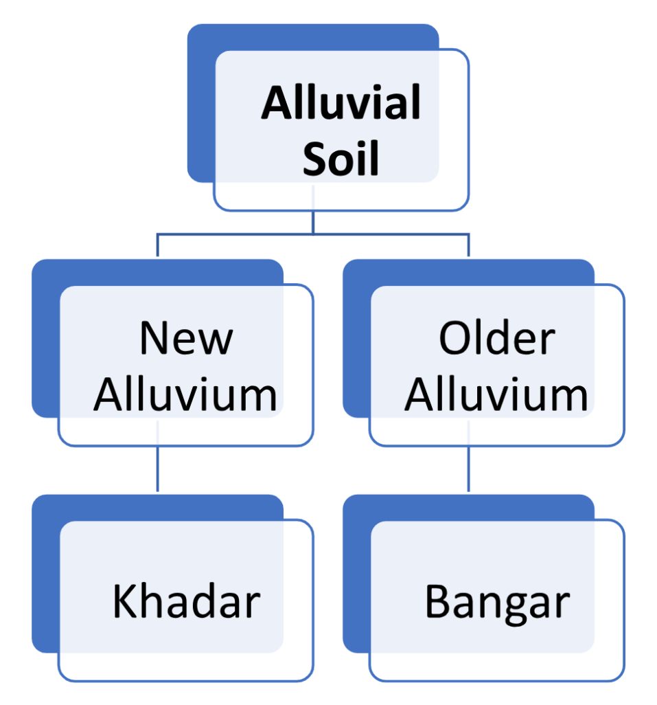
Note: Both the Khadar and Bhangar soils contain calcareous concretions (Kankars).
- Black soil covers most of the Deccan Plateau which includes parts of Maharashtra, Madhya Pradesh, Gujarat, Andhra Pradesh, and some parts of Tamil Nadu. These soils are also known as the ‘Regur Soil’ or the ‘Black Cotton Soil’.
- Laterite has been derived from the Latin word ‘Later’ which means brick. The laterite soils are commonly found in Karnataka, Kerala, Tamil Nadu, Madhya Pradesh, and the hilly areas of Odisha and Assam.
- Yellow and red soils are also found in parts of Odisha and Chhattisgarh and in the southern parts of the middle Ganga plain. The soil develops a reddish colour due to a wide diffusion of iron in crystalline and metamorphic rocks.
S16. Ans. (d)
Sol. The Moho’s discontinuity, also known as the Mohorovicic discontinuity or Moho is the boundary between the Earth’s crust and the mantle. The mantle extends from Moho’s discontinuity to a depth of 2,900 km. “Discontinuity” is used for a surface at which seismic waves change velocity.
- The boundary between the mantle and the outer core is called the Gutenberg discontinuity, which is located at a depth of about 2900 km beneath the Earth’s surface.
- The boundary between the outer core and the inner core is called the Lehmann discontinuity, which is located at a depth of about 5150 km beneath the Earth’s surface.
S17. Ans. (d)
Sol. The El Niño phenomenon is associated with global warming. El Niño is a climate pattern that occurs irregularly in the tropical Pacific Ocean every few years. It is characterized by the warming of the sea surface temperature in the central and eastern tropical Pacific, which can have significant impacts on weather patterns around the world.
- This warming of the Pacific Ocean is linked to global warming, which is the long-term increase in Earth’s average surface temperature due to human activities, such as burning fossil fuels.
- Cloud bursting, earthquakes, and acid rain are not directly associated with the El Niño phenomenon. Cloud bursting refers to a localized, heavy precipitation event, an earthquake is a geological event, and acid rain is caused by air pollution from human activities.
S18. Ans. (c)
Sol. Jet streams are narrow bands of strong wind in the upper levels of the atmosphere, more particularly, the troposphere.
- It follows the wave path near the tropopause at an elevation of 8 km to 15 km.
- They are generally continuous over a long distance and can be thousands of miles long also.
- In reality, the Polar Front Jet Stream (also known as the Midlatitude Jet Stream) is strongest during the winter season, and it becomes weaker during the summer. Therefore, option (c) is not correct.
S19. Ans. (b)
Sol. The country Brazil is located in the continent of South America. Therefore, option (b) “South America” is the correct answer.
- Brazil is the largest country in South America and the fifth largest country in the world, both by land area and by population. It shares borders with all South American countries except for Chile and Ecuador. The capital of Brazil is Brasília, and the official language is Portuguese.
S20. Ans. (a)
Sol. Australia is the smallest continent that lies entirely in the Southern Hemisphere and is also referred to as the ‘Island continent’ due to its isolation from other major landmasses. Thus, option (a) is correct.
- It is surrounded by the Indian and Pacific Oceans and is located between Asia and Antarctica. Australia is the sixth-largest country in the world by land area and the largest country in Oceania. Its capital is Canberra, and the official language is English.


 CBSE Junior Assistant Previous Year Pape...
 RRB ALP Previous Year Question Papers, D...
 RRB Group D Previous Year Papers, Downlo...